Navionics Gear Review – BlueChart g3 Vision marine charts and LakeVü g3 and LakeVü g3
Navionics
Gear Review: Now available, BlueChart®g3, BlueChart g3 Vision marine charts and LakeVü g3 and LakeVü g3 Ultra lake maps for Garmin chartplotters and MFDs
Marine Charts:

BLUECHART® G3• Experience unparalleled coverage and brilliant detail when you’re on the water. BlueChart g3 coastal charts provide industry leading coverage, clarity and detail with integrated Garmin and Navionics content. The charts also calculate suggested routes with Auto Guidance1.
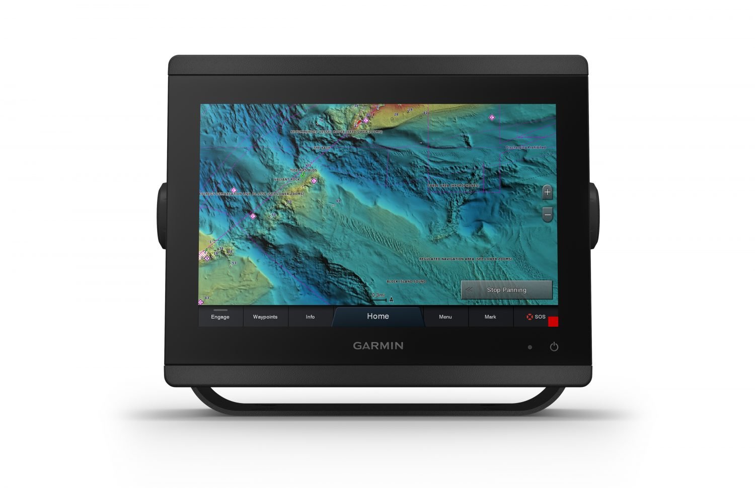
BLUECHART® G3 VISION• BlueChart g3 Vision is our premium chart offering, which includes all the reliability, features and integrated Garmin and Navionics content of BlueChart g3 while adding even more industry-leading features such as high-resolution elevation shading, to help you along your journeys.
The features listed below are available on BlueChart g3 and BlueChart g3 Vision.
ADVANCED CHART DETAIL – Highly detailed charts with Navionics data help mariners guide their boats in and out of port with confidence.
DETAILED CONTOURS – BlueChart g3 features up to 1′ contours that provide a more accurate depiction of bottom structure for improved fishing charts and enhanced detail in swamps, canals and port plans.
AUTO GUIDANCE – Charts include Auto Guidance1technology to calculate suggested routes.
DEPTH RANGE/SHALLOW WATER SHADING – High-resolution depth range shading for up to 10 depth ranges and shallow water shading for a user-defined depth gives a clear picture of shallow waters to avoid.
RASTER CARTOGRAPHY – Download NOAA raster areas for free via the ActiveCaptain® app to provide enhanced clarity and consistency. U.S. only.
The features listed below are available on BlueChart g3 Vision.
HIGH-RESOLUTION RELIEF SHADING – Highly detailed shading that combines color and shadow to provide an easy-to-interpret, clearer view of bottom structure than contour lines alone
HIGH-RESOLUTION SATELLITE IMAGERY – High-resolution satellite imagery overlaid onto navigational charts provides a realistic view of your surroundings.
AERIAL PHOTOGRAPHY – Pictures show exceptional detail of many ports, harbors and marinas. This is ideal when entering unfamiliar ports.
3-D VIEWS – MarinersEye and FishEye views provide 3-D representations of the surrounding area above and below the waterline.
Lake Maps:
LAKEVÜ G3• LakeVü g3 inland maps provide industry-leading coverage, clarity and detail with integrated Garmin and Navionics® content. The charts also calculate suggested routes with Auto Guidance1. You’ll get coverage on more than 17,000 lakes with up to 1’ contours.
LAKEVÜ G3 ULTRA• Our premium inland map collection, divided into East and West regions, includes all the industry-leading features of LakeVü g3, while adding extra mapping features such as high-resolution elevation shading and more than 150 Garmin Elite Survey Lakes.
The features listed below are available on LakeVü g3 and LakeVü g3 Ultra.
1’ CONTOURS – Up to 1′ contours provide a detailed and clear view of the the lake floor so you can catch more fish and navigate with confidence.
AUTO GUIDANCE – The charts also calculate suggested routes with Auto Guidance1.
DEPTH RANGE/SHALLOW WATER SHADING – High-resolution depth range shading for up to 10 depth ranges and shallow water shading for a user-defined depth gives a clear picture of shallow waters to avoid.
The features listed below are available on LakeVü g3 Ultra.
HI-RESOLUTION RELIEF SHADING – Highly detailed shading combines color and shadow to provide an easy-to-interpret, clearer view of bottom structure than contour lines alone
SONAR IMAGERY – Sonar imagery shows a nearly photographic view of the bottom, as if all the water had been drained away
DYNAMIC LAKE LEVEL – Adjust your maps to the lake’s current water levels to see if spots are accessible or too shallow to explore.
HIGH RESOLUTION SATELLITE IMAGERY – High-resolution satellite imagery provides superior situational awareness.
3-D VIEWS – MarinersEye and FishEye views provide 3-D representations of the surrounding area above and below the waterline.
Also available, Canada LakeVü g3gives you coverage on more than 13,500 total lakes, 4,800 of which have up to 1’ contours that provide clearer lake floor views, allowing you to catch more fish and navigate with confidence. Canada LakeVü g3 Ultrapremium inland maps include everything available with Canada LakeVü g3 and add:
High-resolution Relief Shading to make it easier to see contours and find fish holding structure
Unique 3-D views such as MarinersEye and FishEye for additional perspective both above and below the waterline
Dynamic Lake Level adjusts the map based on current water levels
1Auto Guidance is for planning purposes only and does not replace safe navigation operations.